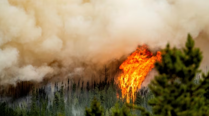
Campfire ban in place for most of B.C., state of emergency for Stikine announced as wildfire numbers spike

British Columbia is imposing a campfire ban across the province, excepting only Haida Gwaii, as well as a state of emergency for the Stikine Region in the province’s northwest corner.
“I think what’s clear to me is the climate crisis is here,” said B.C. Minister of Emergency Management and Climate Readiness Bowinn Ma during a media briefing Monday afternoon.
“We are seeing more climate events, major fires and droughts. This is an extremely challenging time for people and communities. It is immensely stressful.”
The campfire ban goes into effect at 3 p.m. PT. Campfire bans were previously put in place for much of the province earlier this month.

Cliff Chapman, director of provincial operations for B.C. Wildfire Service, said the situation this year has necessitated an “all hands on deck” approach.
“We do not have the capacity right now to respond to fires that we can prevent, and those are the human-caused fires.”
Tactical evacuation
The province enacted the state of emergency for the Stikine because the region is unincorporated, Ma said, prompting a need so the province could put the necessary resources in place in that area.
Emergency personnel had to undertake a tactical evacuation in the area because of the wildfire situation over the weekend, Ma added.
A state of emergency is not needed for the rest of B.C., Ma said, because the Wildfire Act gives the province the tools needed to coordinate provincial and international resources to combat wildfires.

Ma said there are currently about 156 people under evacuation order and 629 people under evacuation alert across the province.
“We are anticipating continued extreme fire behaviour and all of us need to do our part to prevent the situation from becoming any worse, no matter where we are in the province,” she said.
Unprecedented drought
The minister also spoke at length about the severe state of drought currently throughout the province, saying it was unprecedented.
“Knowing there may be increasingly tight water restrictions to ensure there is enough water for essential purposes is also extremely difficult,” Ma said.
Much of the province was already experiencing drought last winter, Ma said. When the ground froze that precipitation didn’t get absorbed into the ground, which she says is part of what has worsened the wildfires this year.
Half of the province’s water basins are currently at Level 4 drought, she said, with Level 5 being the worst.
Many regions have already implemented water restrictions, Ma said, and the province is in discussions with others to implement more.
She said the primary areas of concern at the moment are the northeast, the Lower Mainland and Vancouver Island.
315 active fires in B.C.
The wildfire service was reporting 315 active fires in B.C. on Monday afternoon, most of them concentrated in the Interior.
Almost 200 of the fires are rated as out of control.
Of the 13 blazes listed as “fires of note,” all but two are located in the Prince George and Northwest fire centres, and 12 have prompted at least one evacuation order, although no major communities are threatened.
Some of the fires are threatening rural highways, including Highway 27 south of Fort St. James and Highway 77 north of Fort Nelson, while flames first spotted last Thursday near the Yukon border now cover 300 square kilometres close to Highway 37, but aren’t immediately affecting the link to Watson Lake and Whitehorse.
A wildfire in Yukon has roughly tripled in size since Sunday and remains out of control. Charring about three square kilometres of bush in the Ibex Valley, about 30 kilometres due west of Whitehorse, south of the Alaska Highway, it prompted an evacuation alert for numerous properties along the route.
B.C.’s wildfire danger was high to extreme across all but small pockets of the province on Monday.
Thunderstorms, hot weather in the forecast
Environment Canada posted a severe thunderstorm watch for the Fort Nelson and Peace River regions, the same area where large fires forced evacuations in July.
The weather office noted daily high temperature records were set in the province Sunday, including a high of 33 C in Fort Nelson, two degrees hotter than the previous record for that northeastern community, set 64 years ago.
Forecasters said Nakusp in B.C.’s southeast also posted a sizzling 37.2 C on Sunday, edging its old mark set 22 years earlier, and while no daily highs were posted in Yukon, that territory remains under heat warnings stretching almost 500 kilometres from its boundaries with B.C. and the Northwest Territories north to Mayo.
Conditions could ease slightly in B.C. by Tuesday, but Environment Canada said cooler weather was not likely in Yukon for several more days.
The emergency management ministry said low rainfall and other precipitation over the past year had seen drought conditions worsen in B.C., with most water basins now at Level 4, on a five-level drought scale. Level 4 drought involves extremely dry conditions, with adverse effects of socioeconomic conditions and ecosystems likely.
Related News
Congress ups pressure to release boat strike video with threat to Hegseth’s travel budget
Stefani Reynolds/Bloomberg via Getty Images US lawmakers are trying to pressure the Trump administration toRead more
2 U.S. fighter jets fly over Gulf of Venezuela as lawmakers demand answers on boat strikes
The world’s largest aircraft carrier, the USS Gerald R. Ford, arrived in St. Thomas, U.S.Read more
